March 1, 2008
New Radar Maps of the Moon
Do you like this story?
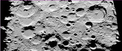
NASA has obtained new high-resolution radar maps of the Moon's south pole--a region the space agency is considering as a landing site when astronauts return to the Moon in the years ahead.
"We now know the south pole has peaks as high as Mt. McKinley and crater floors four times deeper than the Grand Canyon," says Doug Cooke, deputy associate administrator for the Exploration Systems Mission Directorate at NASA Headquarters. "These data will be an invaluable tool for advance planning of lunar missions."
Scientists at NASA's Jet Propulsion Laboratory collected the data using the Goldstone Solar System Radar located in California's Mojave Desert. Three times in 2006, JPL scientists targeted the moon's south polar region using Goldstone's 70-meter radar dish. The antenna, three-quarters the size of a football field, sent a 500-kilowatt strong, 90-minute long radar stream 231,800 miles to the Moon. The radar illuminated the rough-hewn lunar surface over an area measuring about 400 by 250 miles. Signals were reflected back to two of Goldstone's 34-meter antennas on Earth. Scientists have been analyzing the echoes ever since, and the data were released by NASA for the first time this week.
"I have not been to the Moon, but this imagery is the next best thing," says Scott Hensley, a scientist at JPL and lead investigator for the study. "With these data we can see terrain features as small as a house without even leaving the office."
NASA is eying the Moon's south polar region as a possible site for future outposts. The location has many advantages; for one thing, there is evidence of water frozen in deep dark south polar craters. Water can be split into oxygen to breathe and hydrogen to burn as rocket fuel--or astronauts could simply drink it. Planners are also looking for "peaks of eternal light." Tall polar mountains where the sun never sets might be a good place for a solar power station.
These are the highest-resolution maps to date. The best images, previously, were generated by the Clementine spacecraft, which could resolve lunar terrain features near the south pole at 1 kilometer per pixel. The JPL radar maps are 50 times more detailed.
As wonderful as they are, however, these images will pale in comparison to next-generation photos from NASA's Lunar Reconnaissance Orbiter. The spacecraft is scheduled to launch in late 2008 and its camera will beam back photos of the moon with details as small as 1 meter.
"The south pole of the Moon," says Cooke, is going to be "a beautiful place to explore."
Subscribe to:
Post Comments (Atom)


0 Responses to “New Radar Maps of the Moon”
Post a Comment